
All your surveying, on your Mac.
The first and only surveying suite for macOS in the world — with the same three modules as the Windows edition, directly inside iCADMac / IntelliCAD, native on Apple Silicon.
iCADMac / IntelliCADGGRS87 / HEPOS / KAEKNative Apple Silicon
SurveyingMaps, cadastre, points, GGRS87 coordinates and drafting.
KAEK, forest maps, TEE mapCadastral data and the Unified Digital Map in the drawing.
DGM — Geometric ChangesDiagram, tables, checks, signature & ZIP.
Terrain — Surfaces & VolumesTerrain models, volume calculations, profiles & cross sections.
The pictures are real screenshots with Topo Tools at work — from iCADMac and, where noted, from the Windows edition (same commands). Click an image to enlarge it.
The first surveying suite for macOS — now complete
Topo Tools is the first and only suite of specialised surveying commands for macOS in the world. It installs inside iCADMac and adds its own ribbon with surveying, cadastre and earthworks tools — it is not a separate program. You work on your Mac, with your data georeferenced in GGRS87.
The Mac edition is now on par with the Windows edition: live maps inside the drawing, georeferencing of Google imagery directly in HEPOS, Hellenic Cadastre orthophotos for all of Greece, KAEK with vertical properties, automatic Geometric Change Diagrams and volume calculations with professional reports.
It consists of three independent modules — Surveying, DGM and Terrain — licensed separately but sharing the same logic and the same coordinate systems. Built for the Greek reality, with a Greek interface and support.
- Runs inside iCADMac / IntelliCAD
- Native on Apple Silicon — no Parallels, Boot Camp or Windows
- The same 120+ commands as the Windows edition
- Online license check — offline for up to 7 days
- Signed .pkg installer & automatic updates
On Windows? The same Topo Tools runs on AutoCAD, ZWCAD, GstarCAD, BricsCAD & progeCAD — topotools.xyz.
Why Topo Tools for Mac
Reasons it stands apart from generic tools, manual workflows or Windows in a virtual machine.
A world first
The first suite of specialised surveying commands that runs natively on macOS — not through Windows in a virtual machine.
On par with Windows
Surveying, DGM and Terrain with the same commands and the same results as the Windows edition.
Unique features
Live maps, Google → HEPOS, Hellenic Cadastre orthophotos online, KAEK with vertical properties, automatic DGMs.
Inside iCADMac
No external program — its own ribbon & commands in the CAD you already use on your Mac.
Built for the Greek market
KAEK, forest maps, GGRS87/HATT/TM3, DGM, TEE digital map — all built for Greek data.
Three modules, one logic
Shared coordinate systems & data. Combine them freely or take just one.
Native Apple Silicon
Makes full use of M1/M2/M3/M4 — maximum speed, minimum power consumption.
Easy install & updates
A signed, Apple-notarized .pkg and one-click online updates, directly from CAD.
Secure licensing
License per module, with an online check at every start-up and offline work for up to 7 days — no .lic files.
Surveying — your everyday work
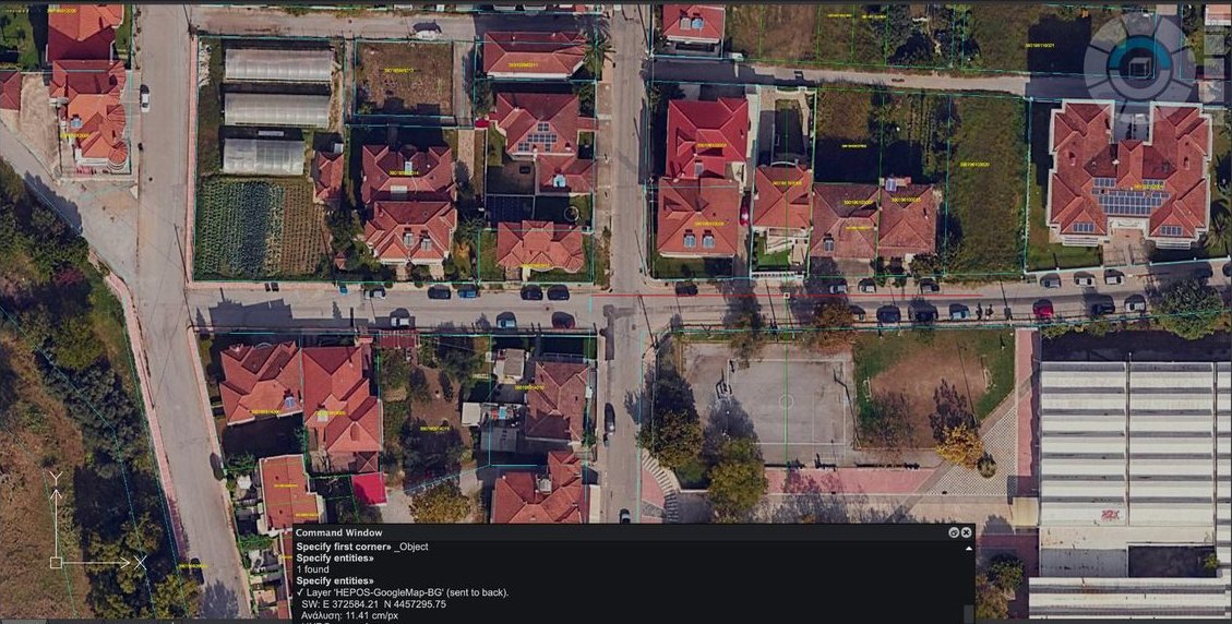
Bring maps, orthophotos and cadastral data into the drawing, work with GGRS87 coordinates and finish the drafting — all georeferenced, inside iCADMac.
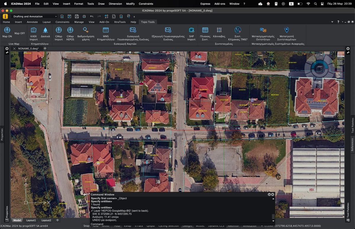

«Topo Tools» tab: Live Map, Cadastre, Map Import, Coordinates, Transformations, Drafting, Info (screenshot from the Windows edition — same commands in iCADMac). Click the image to enlarge it.
All the commands at a glance
What each command of the Surveying module does.
| Command | What it does |
|---|---|
| Cadastre & maps | |
 KAEK parcelsKAEKIMPORT · KAEK | Download & insert KAEK parcels from the Hellenic Cadastre server, georeferenced in GGRS87 — including exclusive uses (vertical properties). |
 Live mapGMAPON · GMAPOFF | Live satellite background or orthophoto that refreshes on every zoom/pan (Google Hybrid, Satellite, OpenStreetMap). |
 Google image in GGRS87IMPORTGMAP · IGMAP | Import a georeferenced satellite image in GGRS87, with a world file. |
Google image in HEPOSIMPORTGMAP_HEPOS · IGMAPHEPOS | Import an image directly into the HEPOS system — with self-learning calibration: it learns local offsets from field measurements and applies them to every subsequent import. |
 Hellenic Cadastre orthophotosIMPORTWMS · IWMS | Hellenic Cadastre orthophotos (WMS) across Greece, automatically georeferenced. |
 TEE Unified Digital MapTT_SDIGMAP | TEE maps & diagrams (Unified Digital Map). |
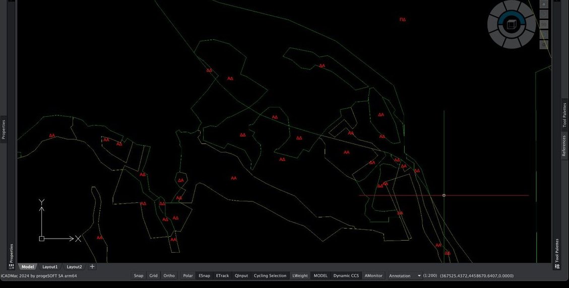
 Forest mapsDASIKA | Import the ratified forest map from the Ministry of Environment service — automatic categorisation and colouring by category. |
| Data & points | |
 ShapefilesIMPORTSHP | Import ESRI Shapefiles (.shp + .dbf) — choose DBF fields as labels. |
 KML / KMZIMPORTKML · EXPORTKML | Import/export KML/KMZ (Google Earth). |
 Point importIMPORTPOINTS | Import points from TXT/CSV with column mapping (ID, E, N, H, description). |
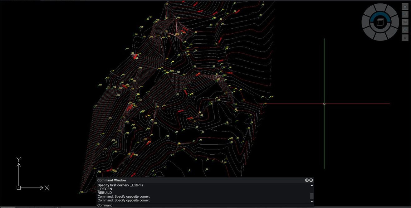
 ContoursCONTOURS | Contours from points: Delaunay, major/minor, Catmull-Rom smoothing, parallel labels. |
 DEM contoursDEM_CONTOURS | Contours from a digital terrain model (DEM). |
| Coordinates | |
 TransformationsGRT · GRTSEL · GRTBATCH | Coordinate transformations of entities: GGRS87 ↔ HATT ↔ TM3 ↔ WGS84 — also in batch. |
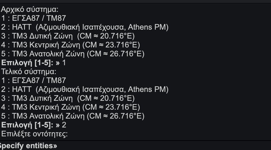
 TM87 / HATTTM87 · TM87SF | TM87 scale factor at any point and HATT sheet selection. |
 GridGRIDCREATE | Create a grid snapped to multiples, with adjustable step and labels. |
| Images & raster | |
 Image georeferencingRUBBERSHEET · GEOREF | Image georeferencing with control points (rubber sheet). |
 Raster croppingIMGCROP · ICROP | Raster cropping that keeps the georeference. |
 Image export / insertIMGEXPORT · MAPIINSERT | Export a georeferenced image with a world file and insert one with automatic placement from its world file. |
| Drafting & delivery | |
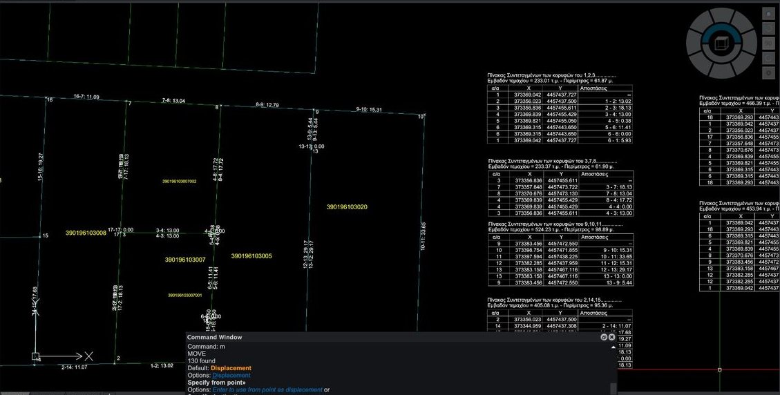
 Coordinate tablesTPSM · TOPOSYNT_MULTI | Automatic vertex coordinate tables per parcel — area, perimeter, distances. |
 Drafting aidsDRAWINGAID · DAID | Drafting aids & drawing settings. |
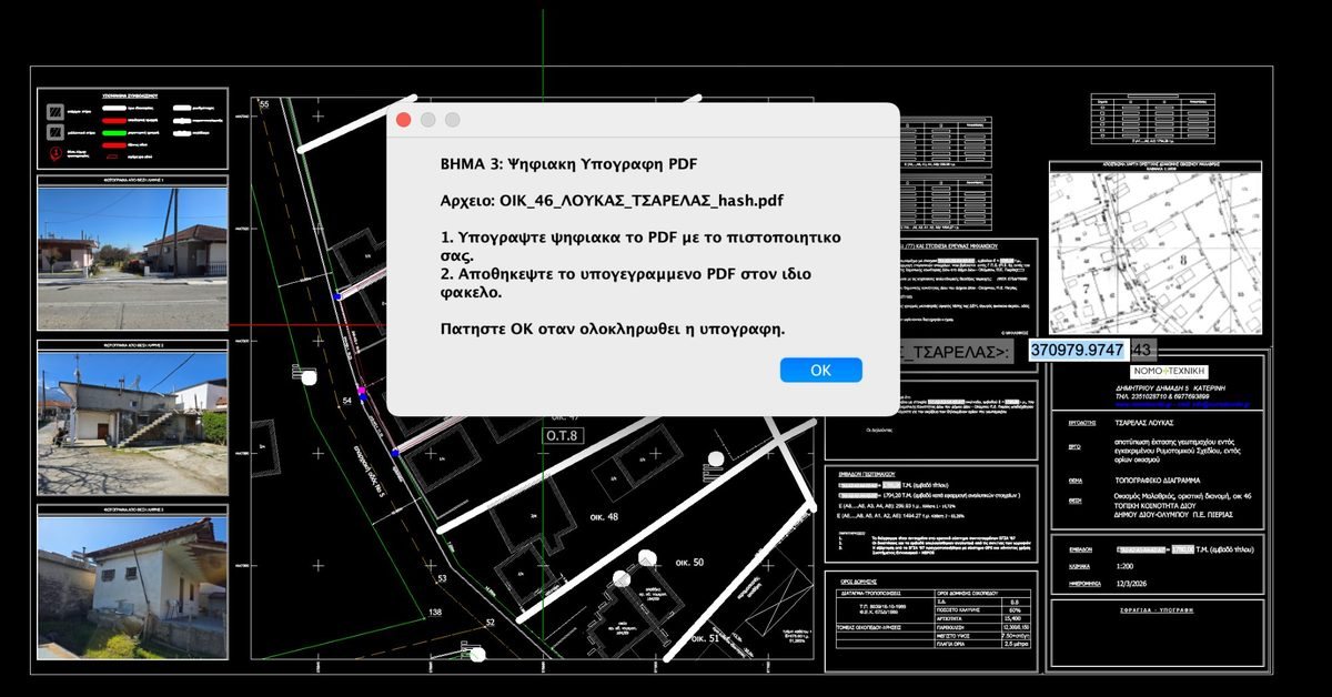
 Signature & ZIPDIAG_SignAndZip | DXF export, SHA-512 hash, PDF digital signature and ZIP for the Hellenic Cadastre portal (Law 4409/2016). |
Things only Topo Tools does
Capabilities you won't find in any other surveying program — let alone on a Mac.
Google → HEPOS, not only GGRS87
Brings georeferenced imagery directly into the HEPOS system — not just GGRS87 (EPSG:2100) — with self-learning calibration from field measurements.
Hellenic Cadastre orthophotos, everywhere in Greece
Live import of Hellenic Cadastre orthophotos with flawless georeferencing across Greece — in the right place, without 1–2 metre offsets.
KAEK + exclusive uses (vertical properties)
We don't just bring KAEK parcels · we also bring the exclusive uses — vertical properties — straight from the Cadastre into CAD.
TEE Unified Digital Map — Vector & Raster automatically
Automatically brings vector data and digital diagrams (raster) from the TEE Unified Digital Map, georeferenced inside the drawing — without leaving the software or downloading files.
The whole country in seconds — Raster & Vector
With the TT_SDIGMAP command you connect directly to the TEE Unified Digital Map and bring into iCADMac digital diagrams (Raster) and vector data (Vector), georeferenced and ready — for any area of Greece.
Raster digital diagrams
Scanned surveys & diagrams (Government Gazette, planning acts) come in with one click — automatic georeferencing in the right place.
Vector data
Boundaries, street layouts, diagrams and geometries arrive as real vector objects — editable, on proper layers and in GGRS87.
Speed across Greece
From the most remote countryside to the city centre, the import takes seconds.
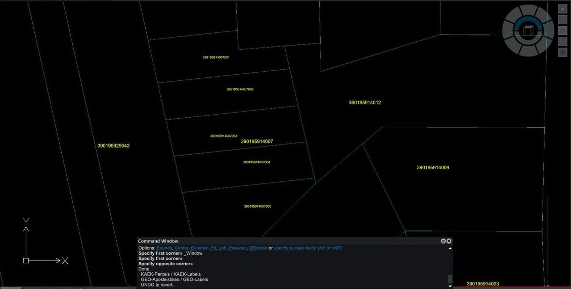
KAEK import
KAEK parcels with their numbers, straight from the Hellenic Cadastre and georeferenced in GGRS87 — inside iCADMac.
Forest maps
Ratified forest map coloured by category (AA / DD / AD).
Digital signature & ZIP
DXF export → SHA-512 hash → PDF digital signature → ZIP, ready for the Hellenic Cadastre portal (Law 4409/2016).
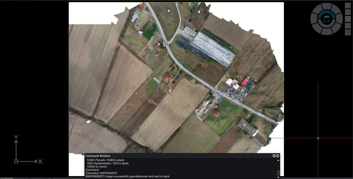
What you can do
The core module covers the whole surveying workflow: backgrounds and cadastral data inside the drawing, point and contour management, conversions between all Greek projection systems, and drafting tools for fast delivery.
Maps & backgrounds
- Live map (real-time zoom/pan)
- Hellenic Cadastre WMS orthophoto & HEPOS
- Georeferencing, calibration, cropping & rubber-sheeting
Cadastre
- KAEK import with labels inside the polygon
- Forest maps & TEE Unified Digital Map
- Digital signature & ready-made ZIP (PDF)
Data & points
- Point import & automatic contours
- Import SHP · Import/Export KML & KMZ
- Drafting aids, text & layers
Coordinates & delivery
- GGRS87 / TM87, HATT (387+), TM3, WGS84
- High-accuracy two-way transformations
- Vertex numbering & grid
- Export of tables & coordinate files
- Georeferenced deliverables ready for submission
Workflow — 5 steps
Cadastre
Geometric Change Diagrams
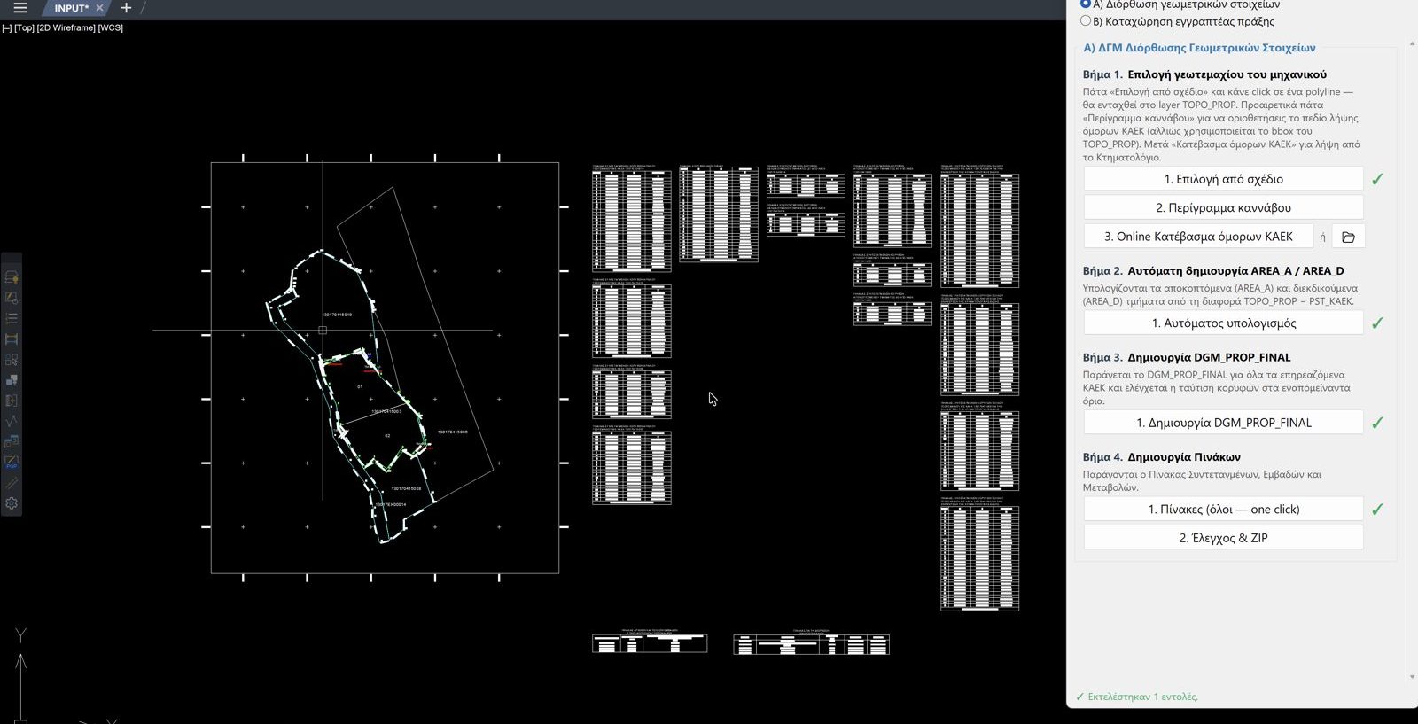
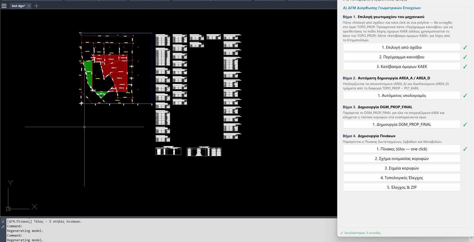
Automated DGM production from digitising to signing: diagram, tables, validity checks and a submission-ready package — now on the Mac too.
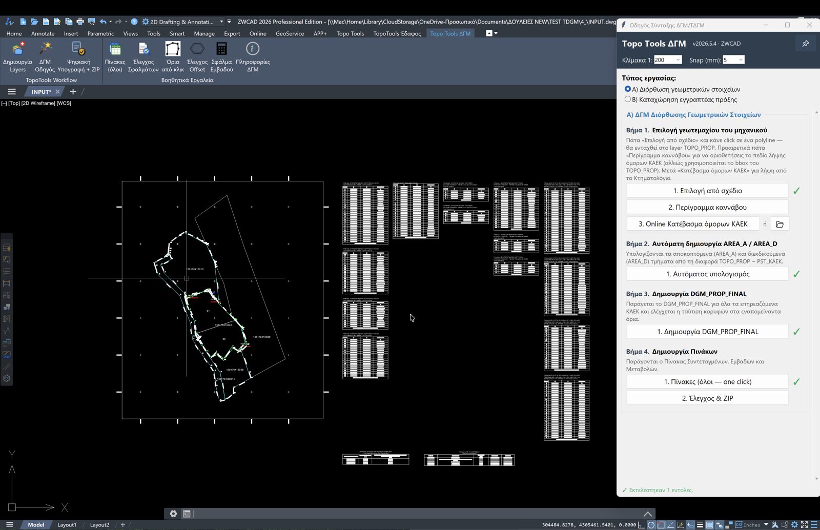
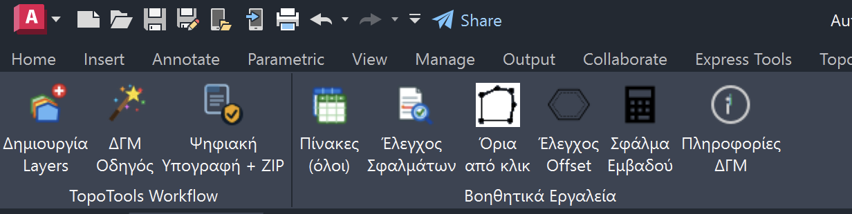
«Topo Tools DGM» tab: Workflow (Layers, Wizard, Digital Signature + ZIP) & Helper Tools (Tables, Checks, Errors, Areas) — screenshot from the Windows edition — same commands in iCADMac.
The fastest & easiest DGM
Fewer clicks, fewer mistakes, ready for submission.
Always-On Wizard — step by step, for every type of DGM
The only and first program with a permanent Always-On Wizard that guides you step by step so you can complete every type of Geometric Change Diagram with incredible speed and ease.
From digitising to DGM in a few clicks
The wizard takes you step by step — subdivision, vertical property creation, merging — with automatic snapping of lines to boundaries.
Automatic tables & diagrams
Change, coordinate and area tables are generated automatically — not by hand.
Validity checks + ready for submission
Built-in completeness/topology checks and signing — a submission-ready package.
Preparing a DGM step by step
Watch the workflow for preparing a Geometric Change Diagram — from the input data to the geometry correction (video from the Windows edition; the workflow is the same in iCADMac).
Not playing here? — open it on YouTube.
Commands — DGM
What each command of the Geometric Change Diagrams module does.
| Command | What it does |
|---|---|
| Wizard & drafting | |
 DGM wizardDGM_WIZARD | The DGM wizard — step by step: subdivision, vertical property creation, merging. |
 Engineer's polygonsDGM_SELECT_TOPO | Selects the engineer's polygons to be processed. |
 Subdivision/vertical linesDGM_LINEXM_SESSION | Draws subdivision/vertical property lines with automatic boundary checking. |
 Vertex numberingDGM_VERTEX_NAMING · DGM_VERTNUM | Vertex numbering & naming. |
 Title & declarationDGM_TITLE · DGM_DECL | Diagram title & declaration/solemn declaration. |
| Tables | |
 All tablesDGM_TABLES_ALL · DGM_TABLE | Generates all DGM tables automatically. |
CoordinatesDGM_COORDFILE | Vertex coordinate table/file. |
 AreasDGM_AREATBL | Area table. |
 DistancesDGM_DISTTBL | Side distance table. |
 ChangesDGM_METAB | Change table (initial → final state). |
| Checks & submission | |
 Validity checkDGM_CHECK | Validity check — completeness & topology (validator). |
 CorrectionDGM_DIORTHOSI | Correction of geometry & discontinuities. |
 Errors / accuracyDGM_ERRTBL | Error/accuracy table. |
 Export & clean-upDGM_EXPORT · DGM_CLEAN | Export & clean-up of the finished DGM. |
Signature & ZIPDIAG_SignAndZip | Digital signature & compression (zip) — ready for submission. |
Severed & claimed parts
Severed (green) & claimed (red) parts, with automatic tables and automatic area calculation.
What you can do
The DGM module handles the whole preparation of the Geometric Change Diagram: it automatically detects severed and claimed parts, produces the diagram and all tables, and runs validity checks so the deliverable goes through without surprises.
Diagram & tables
- Automatic production of the DGM, title & declaration
- Change, coordinate, distance & area tables
- Area correction & error table
Wizard & splitting
- Guided step-by-step workflow (wizard)
- Automatic parcel splitting
- Severed / claimed parts & joint lawsuit
Checks & submission
- Topology & completeness checks
- Detection of gaps, overlaps & duplicate vertices
- Digital signature & ready-made submission ZIP
Workflow — 5 steps
Earthworks
Terrain — Surfaces & Volumes
Build digital terrain models from any source, generate contours, calculate cut/fill volumes with professional reports, and produce longitudinal profiles & cross sections — on your Mac.

«TopoTools Terrain» tab: Import (DEM, SRTM, LAS/LAZ, points), Surfaces, Longitudinal Profiles, Cross Sections, Help — screenshot from the Windows edition — same commands in iCADMac.
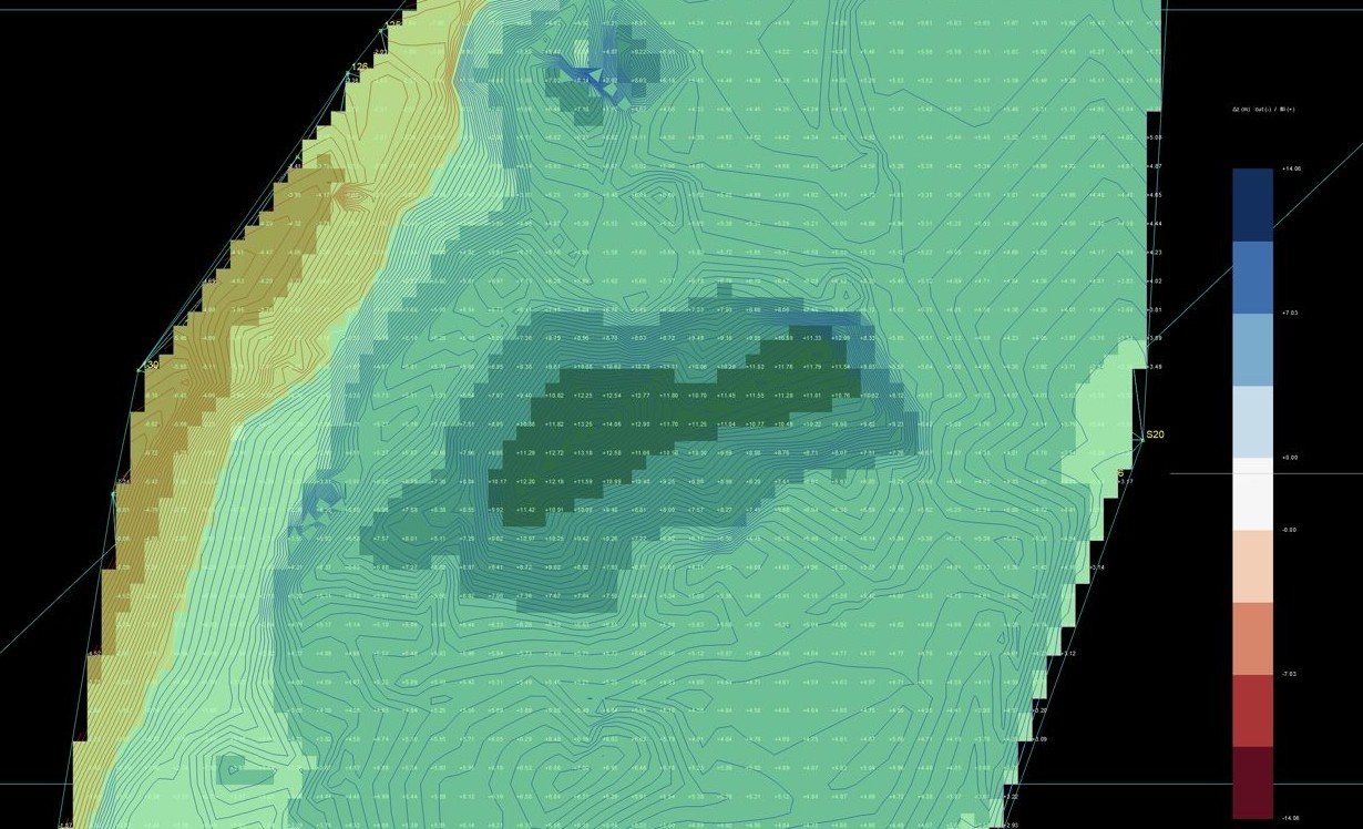
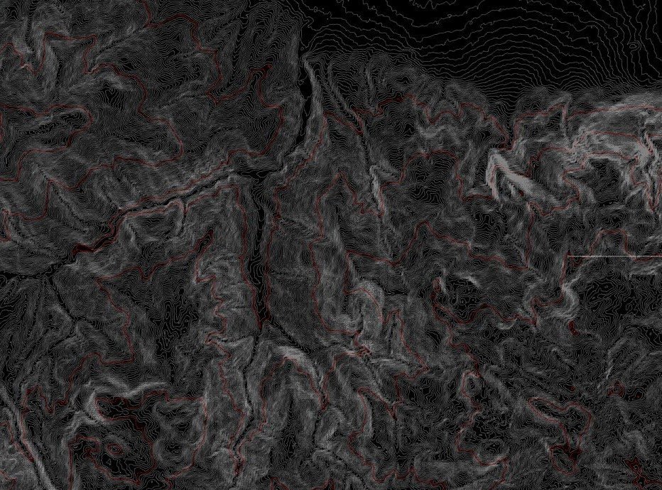
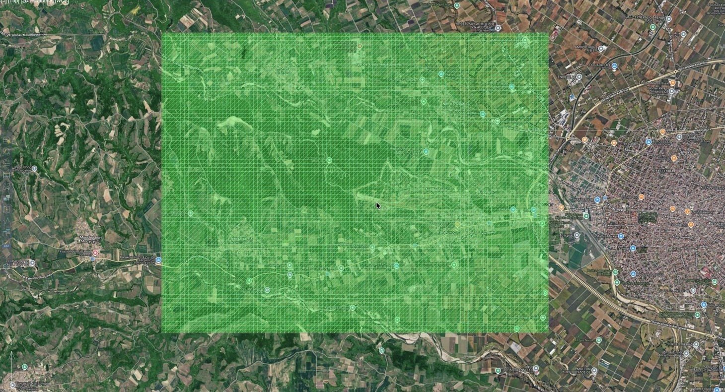
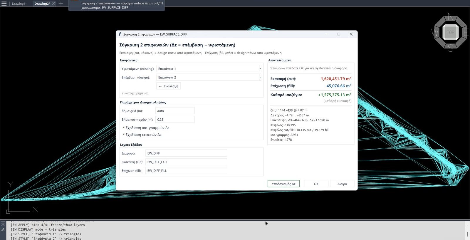
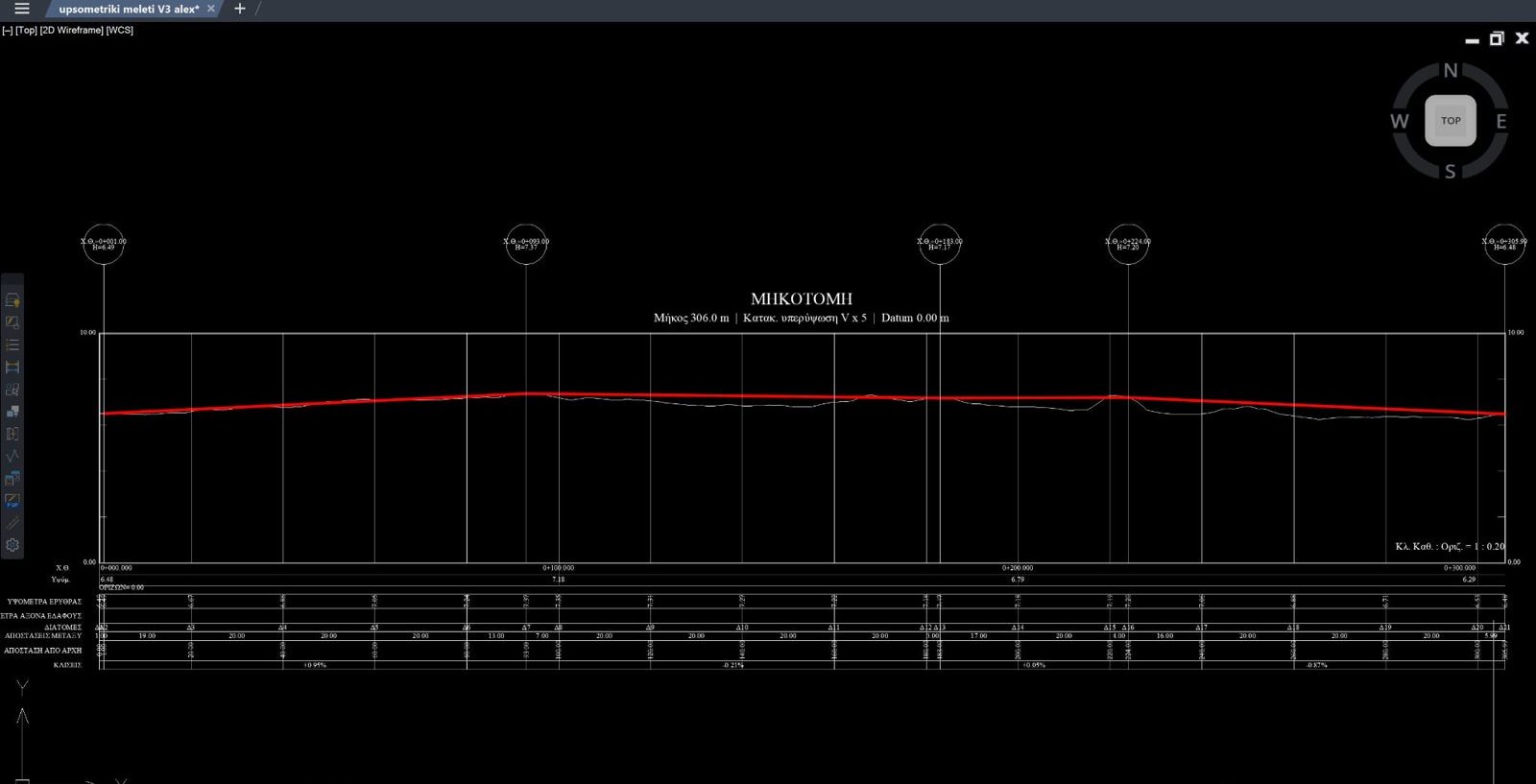
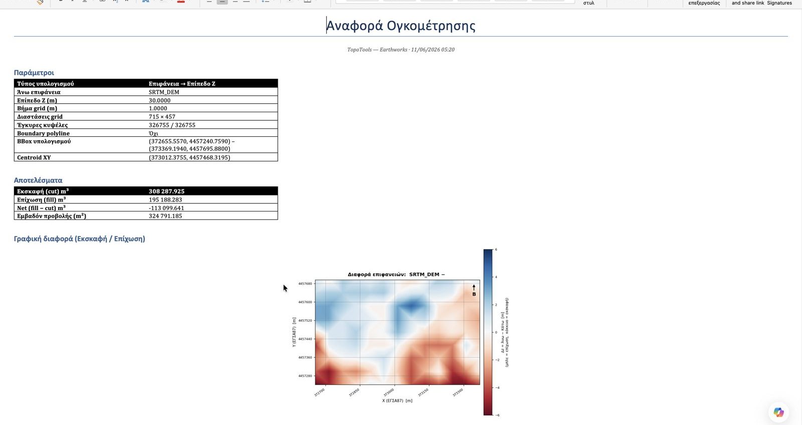
Real screenshots from the Terrain tools — in iCADMac and, where noted, in the Windows edition. Click an image to enlarge it.
A complete earthworks workflow — inside iCADMac
Everything you would need Civil 3D or an external GIS (and Windows) for, inside the CAD on your Mac.
The whole earthworks workflow inside CAD
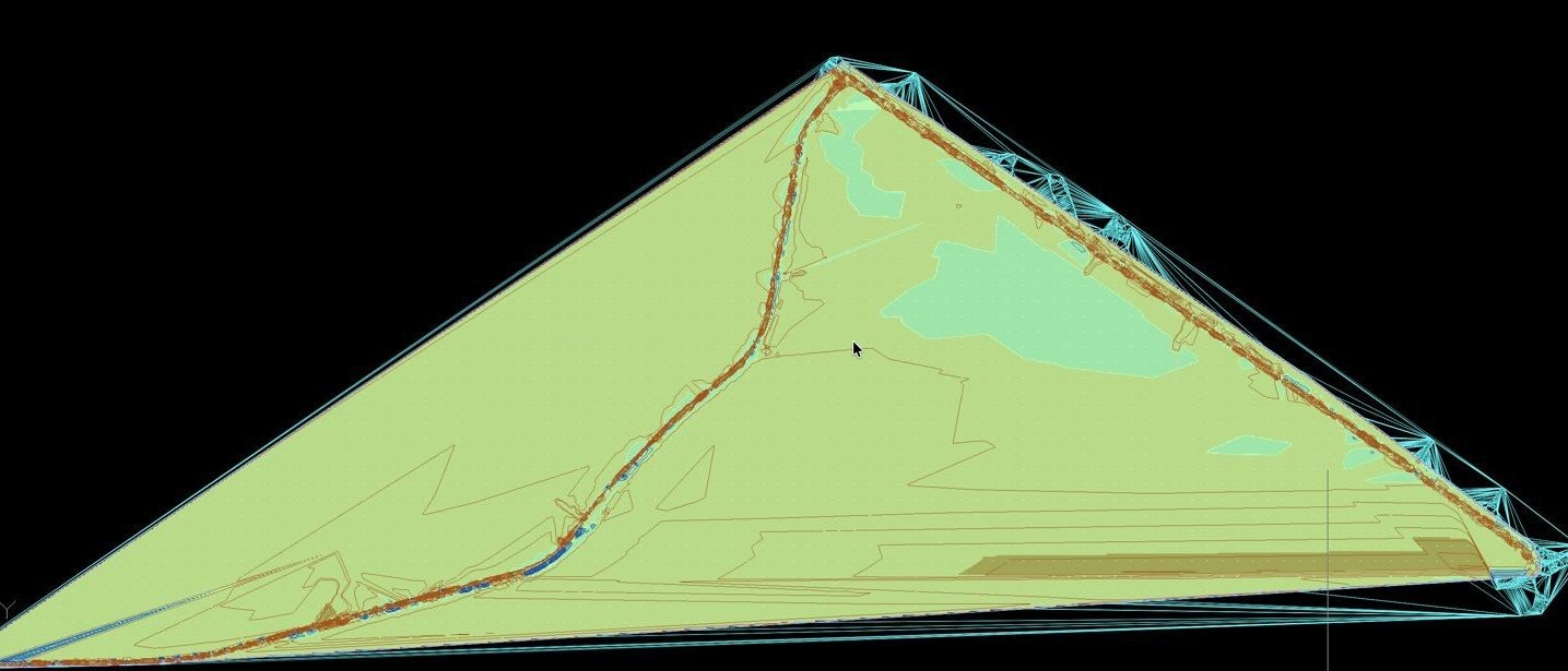
Surfaces, volumes, longitudinal profiles, elevation maps and 3D — without Civil 3D or external software.
LiDAR · SRTM · DEM
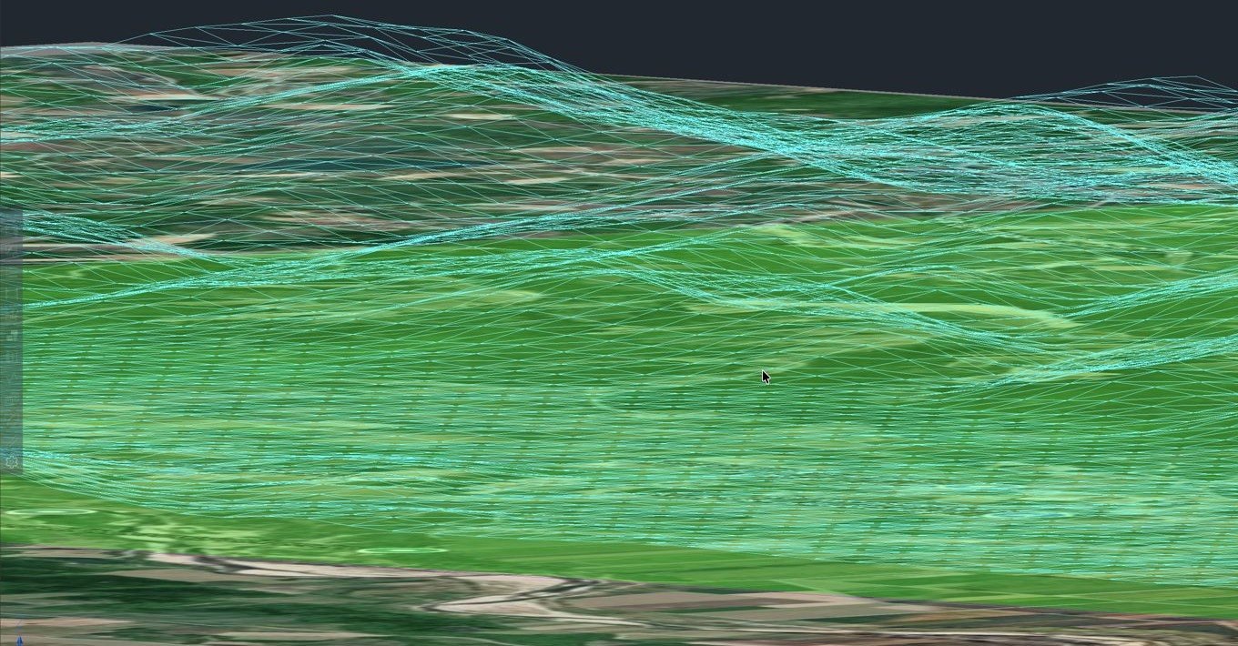
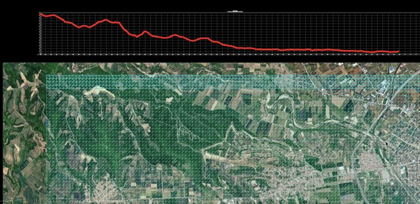
Downloads SRTM/DEM elevation data online and imports LiDAR (LAS/LAZ) point clouds — TINs of millions of triangles, fast.
Cut/fill volumes + Word report
Surface comparison with a colour cut/fill heatmap and an automatic, ready-made Word report.
Workflow — 5 steps
 ImportPoints / DEM / SRTM / LAZ.
 SurfaceCreate & manage the TIN.
 AnalysisContours, display & comparison.
 VolumesCut/fill volumes + heatmap.
 SectionsProfiles/sections & reports.
Commands — Terrain
What each command of the Terrain module does.
| Command | What it does |
|---|---|
| Import & surfaces | |
Surface from pointsEW_SURFACE · EWSURF | Create a surface (TIN) from points. |
 Point importEW_IMPORTPOINTS · EWIPTS | Import points to create a surface. |
 DEM importEW_DEM_IMPORT · EWDEMIMP | Import a DEM & create a surface (millions of triangles). |
 SRTM onlineEW_SRTM_IMPORT · EWSRTM | Download SRTM elevation data online. |
 LiDAR (LAS/LAZ)EW_LAZ_IMPORT · EWLAZIMP | Import LiDAR (LAS/LAZ) point clouds. |
 Surface import / exportEW_SURF_IMPORT · EW_SURF_EXPORT | Import/export of surfaces (LandXML etc.). |
| Management & analysis | |
 Surface managerEW_SURFACES · EWSURFMGR | Surface manager (colour, layer, display). |
 Surface editingEW_SURFACE_EDIT · EWSEDIT | Surface editing — add/delete triangles. |
 Display modeEW_SURF_DISPLAY · EWSDISP | Display mode: triangles / outline / fill / 3D. |
ContoursEW_CONTOURS · EWCTR | Contours from a surface. |
Elevation mapEW_HEIGHTMAP_REGEN | Elevation map (heightmap) with colour rendering. |
 Surface comparisonEW_SURFACE_DIFF · EWSDIFF | Compare two surfaces — elevation difference / heatmap. |
| Volumes & sections | |
Volume calculationEW_VOLUME · EWVOL | Cut/fill volume calculation with a cut/fill graphic & Word report. |
 Longitudinal profilesEW_PROFILE · EWPROF | Longitudinal profiles along an alignment. |
Cross sectionsEW_SECTION · EWSEC | Cross sections (from an alignment or existing lines). |
 Design grade lineEW_REDLINE · EWRED | Design grade line — design line for volumes. |
What you can do
The Terrain module turns data of any format into a usable digital terrain model and covers the whole earthworks chain: contours, surface comparisons, volume calculations with reports, and longitudinal profiles/cross sections for project designs.
Surface creation
- From a point file or points in the drawing
- From DEM, SRTM/Copernicus & LAS/LAZ (LiDAR)
- Management, editing & precise clipping
Analysis
- Coloured contours & editing
- Surface comparison & elevation map
- Display modes: triangles / perimeter / heightmap
Volumes & sections
- Cut/fill volumes with a difference heatmap
- Volume report in Word / PDF
- Longitudinal profiles, design grade line & cross sections (also from existing lines)
What each module includes
The same split as the Windows edition. Some capabilities (e.g. contours, digital signature) are available in more than one module.
| Feature | Surveying | DGM | Terrain |
|---|---|---|---|
| Live map & WMS orthophoto | ✓ | — | — |
| Cadastre (KAEK, forest maps) | ✓ | — | — |
| Import SHP / KML-KMZ / points | ✓ | — | — |
| Coordinates & transformations (GGRS87 / HATT) | ✓ | — | — |
| Geometric Change Diagrams | — | ✓ | — |
| Cadastre tables & checks | — | ✓ | — |
| Severed / claimed parts / joint lawsuit | — | ✓ | — |
| Digital signature & submission ZIP | ✓ | ✓ | — |
| Surfaces (TIN) from DEM / SRTM / LAZ / points | — | — | ✓ |
| Contours | ✓ | — | ✓ |
| Cut/fill volumes & reports | — | — | ✓ |
| Longitudinal profiles & cross sections | — | — | ✓ |
| Elevation map (heightmap) | — | — | ✓ |
Full support for the Greek systems
Geodetic-precision transformations between all the coordinate systems used in Greece — to and from GGRS87. Available in all modules.
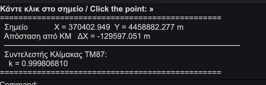
TM87 scale factor
With the TM87SF command you click any point and get the GGRS87 scale factor and the distance from the central meridian — essential for high-precision surveys.
Topo Tools in one video
A look at the workflow inside CAD — from data import to the final result. The same commands are available in iCADMac.
See all the videos on our channel
Not playing here? — open it directly on YouTube.
Pay only for what you need
Each module costs €800 + VAT — or get all three together in a bundle for €2,000 + VAT. License per Mac, with support & updates in Greek and English.
| Module | Includes | Price | |
|---|---|---|---|
| Surveying | Cadastre, KAEK, forest maps, live map, orthophotos, TEE. | 800 €+ VAT · per Mac | Buy a license |
| DGM | Geometric Change Diagrams, automatic tables, checks, ready-made ZIP. | 800 €+ VAT · per Mac | Buy a license |
| Terrain | Surfaces, contours, cut/fill volumes, longitudinal profiles & cross sections. | 800 €+ VAT · per Mac | Buy a license |
| Full suite Best value | All three modules together — Surveying + DGM + Terrain. The most cost-effective option compared with buying separately. | 2,000 €+ VAT · per Macinstead of €2,400 — save €400 | Buy a license |

Free trial
Install Topo Tools and activate a 5-day trial license directly from iCADMac, with a code sent to your email.
Request the trial versionOnline license (no USB token and no .lic file). Multi-seat discounts apply — ask for a quote.
Flexible licensing, per module
You pay only for what you need. The license is checked online at every start-up and keeps working offline for up to 7 days (grace period).
Per module
Separate license for Surveying, DGM and Terrain. If you only license one, the others simply stay inactive — no problem at all.
Online & offline
Online check at every start-up, with offline work for up to 7 days (grace period) and automatic updates.
No UUID & .lic
The Mac identifier is read automatically at activation — no Terminal and no files to send. Everything is shown under «Info».
System requirements
- Operating system
- macOSApple Silicon (M1/M2/M3/M4) — native ARM64
- CAD platform
- iCADMac 2024 or laterIntelliCAD platform for macOS
- Installation
- A .pkg package, signed & notarized by Appleautomatically installs whatever it needs (e.g. Python 3.13)
- Integration
- Ribbon & commands in iCADMacno external application, no Parallels
- Updates
- Automaticonline version check
- Internet
- For the license check, KAEK, live maps, orthophotos, forest maps and updates. Offline for up to 7 days.
Also working on Windows?
The same Topo Tools is available for AutoCAD (+ Civil 3D · Map 3D), ZWCAD, GstarCAD, BricsCAD and progeCAD on Windows — native x64 & ARM64.
Ready in 4 steps
Request the Mac installer and activate a 5-day trial license yourself — from inside iCADMac.
Install & trial
Requires a Mac with Apple Silicon and iCADMac 2024 or later. The Mac identifier is read automatically — no need to send a Hardware UUID.
Try it or get a license
Tell us which modules you are interested in — we will send you the Mac installer and licensing information.
- 5-day trial license before purchase
- License per module — pay for what you need
- Support & updates in Greek and English
Or email us directly — one click opens a ready-made message:
topotools@topotools.xyzStart today — surveying on your Mac
5-day trial license · License per module — pay for what you need
Everything you want to know
Does it work on my Mac?
Yes. Topo Tools integrates directly into iCADMac (IntelliCAD for macOS) with its own ribbon and commands, and runs natively on Apple Silicon — no Parallels, Boot Camp or Windows.
Does it have the same features as the Windows edition?
Yes. The Mac edition is now on par with the Windows edition: Surveying, Geometric Change Diagrams (DGM) and Terrain, with the same commands and the same coordinate systems.
How is it installed?
With a signed, Apple-notarized .pkg package: double-click it and the installer takes care of everything it needs (e.g. Python 3.13) and adds the ribbon to iCADMac.
Can I buy just one module?
Absolutely. Each module is licensed separately at €800 + VAT; all three together cost €2,000 + VAT. If you only license one, the others simply stay inactive and do not affect anything.
Do I need a permanent internet connection?
Not permanent. The license is checked online at every start-up; if there is no connection at that moment, the program keeps working offline for a limited grace period (up to 7 days from the last successful check). Internet is also needed for live maps, orthophotos, KAEK and updates.
Do I need to send my Mac's Hardware UUID?
Not any more. The Mac identifier is read automatically by the activation window — no Terminal and no .lic file needed.
Does it support the Greek coordinate systems?
Yes — GGRS87/TM87, TM3 (Transverse Mercator 3°), HATT (387+ sheets), HEPOS and WGS84, with high-accuracy two-way transformations.
Does it produce a DGM ready for submission?
The DGM module automates the production of diagrams & tables, runs topology/completeness checks and creates a digitally signed ZIP package ready for submission.
Is there a Windows version?
Yes — for AutoCAD, ZWCAD, GstarCAD, BricsCAD and progeCAD. See topotools.xyz.
Contact us
Questions about the tools, licences or a multi-seat quote? Write to us and we will get back to you.
